National Security
They surface as illegal mining, dark vessels, deforestation, smuggling, and communities at risk, spread across agencies that never share one picture. Quatro connects satellite, sensor, and agency data into one sovereign model, so your teams move from detection to approved action with data that never leaves sovereign hands.
What Your Team Gets
Near-real-time detection of illegal mining, deforestation, dark vessels, and land-use violations from satellite earth observation and ground-sensor networks. Spot an illegal clearing or a dredge in days, not months.
Catch the activity while intervention still matters.
Connect a detected mine, vessel, or clearing to the financing, logistics, and command structure behind it. Enforcement targets the operation, not the symptom, so it does not just move and resume.
Target the network, not the single dredge.
Every assessment traces back to its source signal, every action runs through human approval, and the entire model stays inside sovereign infrastructure, air-gapped where required.
High-confidence assessments, full provenance, data that never leaves sovereign hands.
The Structural Problem
Environmental authorities, coast guard, police, and social services each see one piece. The networks behind illegal mining, fishing, and trafficking run one coordinated operation. The asymmetry favors the threat.
What Operators Face
01
By the time illegal mining or deforestation surfaces through manual review, the mercury is in the river and the forest is gone. Damage that satellite detection could catch in days is found months later.
02
Enforcement targets the visible activity, the single dredge or vessel, not the financing, logistics, and command structure behind it. The operation moves and resumes.
03
National intelligence cannot depend on foreign cloud or outside operators. Detection, reasoning, and action must run inside sovereign infrastructure, with full provenance and human authority preserved.
Intelligence Domains
Each domain delivers intelligence from day one — independently. As they connect through a shared sovereign model, a national picture emerges: community signals inform territorial operations, environmental intelligence feeds back into public safety, and every domain compounds the value of every other.
Predictive intelligence that identifies which communities and individuals are most at risk, before intervention is too late. Multi-agency data fusion connects education, health, social services, and law enforcement into parish-level risk scoring and targeted intervention routing.
Youth Risk Index · Education · Health · Social Services · Law Enforcement · Community Intervention
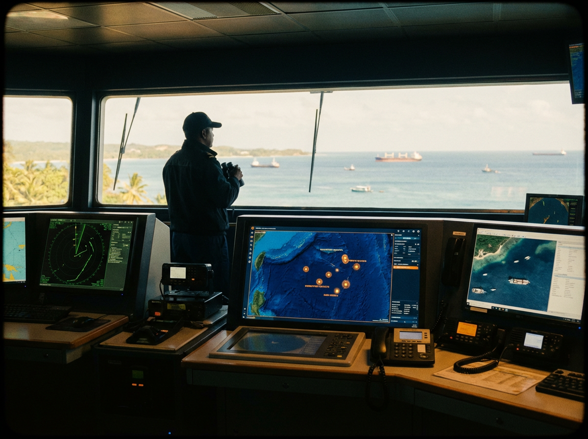
Satellite AIS, radar, and AI-driven detection of dark vessels, illegal fishing, and smuggling routes across exclusive economic zones. Automated enforcement targeting connects coast guard, navy, and fisheries agencies into one maritime operational picture.
Dark Vessel Detection · IUU Fishing · EEZ Enforcement · Coast Guard · Smuggling Interdiction
Satellite earth observation and ground-sensor networks that detect deforestation, illegal mining, and land-use violations in near real-time. Environmental intelligence connected to the criminal networks behind resource extraction, so enforcement targets operations, not symptoms.
Satellite EO · Deforestation · Illegal Mining · Protected Areas · Environmental Crime
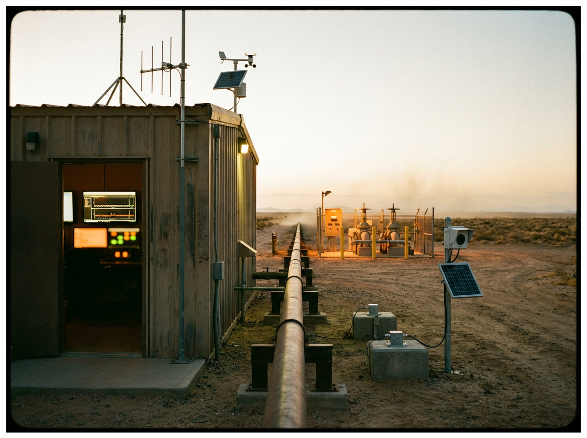
Pipeline theft detection, critical infrastructure monitoring, and SCADA integration that connects physical security systems to operational intelligence. Every sensor, every alert, every response coordinated through a single governed model.
Pipeline Protection · SCADA · Critical Infrastructure · Theft Detection · Energy Security
Multi-sensor border monitoring connecting radar, cameras, ground sensors, and satellite imagery into continuous territorial awareness. Smuggling network analysis, crossing pattern detection, and coordinated multi-agency response, from detection through interdiction.
Border Monitoring · Smuggling Networks · Crossing Patterns · Multi-Agency Response · Territorial Sovereignty
Full Capability Set
04
One picture across every agency the mission touches.
05
Accelerated assessment without removing human judgment.
The Integrator Approach
We don't replace your systems. We connect them. Hardware, software, and the people who run them, in one operational model your team works from.
How It Works
01
Connect satellite earth observation, AIS and radar, ground sensors, OSINT, and agency data streams across environmental, coast guard, police, and social services into one sovereign intelligence model. 8,000+ integrations. Edge processing for air-gapped environments.
02
Spatial-temporal reasoning and domain threat ontologies surface illegal extraction, dark-vessel activity, deforestation, and cross-border movement, and connect each to the network behind it. Every claim traces back to its source.
03
Analyst-in-the-loop workflows coordinate multi-agency response from detection through interdiction. Agents draft assessments and targeting packages; humans approve. Data and action stay inside sovereign infrastructure.
From Our Thinking
platform · 7 min read
Every vendor promises visibility. But when your operation runs 15-30 disconnected systems, visibility isn't a dashboard, it's a structural engineering problem.
industry trends · 8 min read
Physical security, cyber operations, logistics, and space domain awareness each have their own intelligence system. The problem isn't the systems, it's that nobody can see across the boundaries between them.
use cases · 7 min read
Physical security and cyber security report to different commands, run different tools, and generate different alert streams. The compound threat (the one that spans both) lives in the gap between them.
See what industrial AI integration looks like on your national security infrastructure.
Tell us the outcome that matters. We connect the systems that hold the answer. Your team starts working from the model.
Intelligence in weeks · Your team owns it from day one · Data never leaves sovereign hands